The Lac des Fétoules and La Lavey
A path which has fresh, cool mountain streams along the way, and rises up into the world of alpine pastures and the Lac des Fétoules. In the deserted hamlet of La Raja, reconnect with a mountain once inhabited, its ruins and its beliefs, in the heart of a beautiful mixed forest. Above the Refuge de La Lavey, the Lac des Fétules offers lucky walkers the opportunity to take a break with a wide-open view over the entire valley and its glaciers.
Important information
Dans le Parc national des Écrins, les sentiers sont généralement praticables de la mi-juin à fin septembre.
Toutefois, les périodes d'accessibilité des itinéraires et les dates de pose des passerelles varient d’une année à l’autre en fonction de l’enneigement, des dégâts survenus en hiver et des conditions météorologiques. Par ailleurs, l’état des sentiers n’est pas contrôlé quotidiennement et peut évoluer rapidement après un évènement météorologique (orage, crue...). Il est nécessaire de se renseigner auprès des maisons du parc national et des offices de tourisme du territoire avant votre sortie. Pendant la randonnée, en cas de passage dégradé ou dangereux, faites demi-tour et signalez-le.
Description
- Take the path at the back of the car park to drop down to the mountain stream Le Vénéon and its magnificent bridge, the Pont des Rajas.
- Cross the pretty stone bridge and head uphill towards the houses of Les Rajas. Carry on uphill to reach the valley, the Vallon de la Lavey, and follow the right-hand bank of the mountain stream, and then cross to the left-hand bank over a second stone bridge. At the shepherd's hut, cross a gently sloping area of stone slabs until you come to the refuge hidden behind this small glacial rock bar.
- After the refuge, cross the mountain stream La Muande and head towards the Lac des Fétoules. You wind uphill across some screes and grassy slopes until you reach the Lac des Fétoules.
- You then drop relatively steadily until you come to the path leading to the refuge.
- Turn right and follow the outward route in reverse to reach the car park in Champhorent.
- Departure : Champhorent
- Arrival : Champhorent
- Towns crossed : Saint-Christophe-en-Oisans
12 points of interest
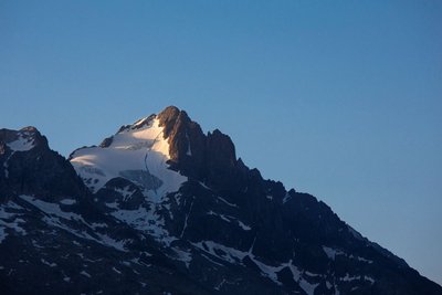
Le glacier et la Tête des Fétoules - Thierry Maillet - Parc national des Ecrins  Top
TopView over Tête des Fétoules
The Tête des Fétoules, a summit in the Ecrins mountains, rises to an altitude of 3,459 metres. Along with the Tête de l'Etret, among others, it is one of a series of peaks separating the Vallon des Etages (to the east) from the Vallon de la Lavey (to the west).
It was first climbed on 29 August 1876 by Emmanuel Boileau de Castelmau with Pierre Gaspard and his son.
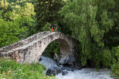
Pont de Pierre sur le Vénéon - Parc national des Ecrins - Thierry Maillet  Vernacular heritage
Pont du Vénéon
Crossing the Vénéon, this superb stone humpback bridge dates back to the seventeenth century. It is an example of the know-how of our forebears, and the fact that this substantial project was undertaken at all is an indication of the importance of this valley. This bridge also constitutes built evidence of the age-old human occupation of the La Lavey valley. The arch of this bridge was restored in 1972. The structure was decrepit and the joints were completely re-grouted. As you cross the bridge, note the colour of the water of the Vénéon. This is due to fine particles in suspension, the result of erosion of the glaciers in the upper reaches of the Vénéon and dissolved silica from the feldspars contained in the crystalline rocks.
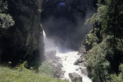
Cascade de la Lavey - Daniel Roche - PNE  Water
WaterLa Lavey waterfall
The valley of La Lavey is crossed by the mountain stream La Muande. One hundred and fifty metres upstream from the confluence of this mountain stream with that of the Vénéon, the valley culminates at a gorge and the La Lavey waterfall.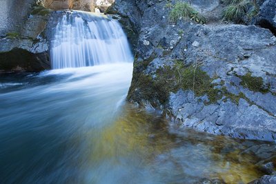
Torrent de montagne - © Parc national des Ecrins - Thierry Maillet WaterMountain streams
Mountain streams are characterised by a sometimes very steep slope and a tumultuous current. Due to the continual intermingling of elements, the water is highly oxygenated and favourable to certain animal species (brown trout, water invertebrates, etc.) that are adapted to the ecological conditions of these ecosystems (even when the water turns to ice !). Mountains streams are also a major factor in erosion due to their role in crushing elements and transporting sediment from the upper slope pools to the large rivers. They represent a very fragile and threatened environment, particularly due to human development, and are among the ecosystems needing to be protected !
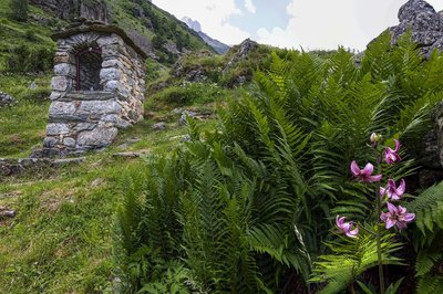
Oratoire de la Raja - Parc national des Ecrins - Thierry Maillet Vernacular heritageOratory of the Virgin and Child in Raja.
In the mountains where the villages are sometimes isolated from each other and too small to have a chapel, oratories were often built. They are mainly small and made of local stone, with an alcove at the centre where a small statue, a plaque or a holy image is placed, representing an important element in religious life. A local place of worship, they are often dedicated to the Virgin Mary or to a saint. They become the goal of a procession or a votive festival for the local population.
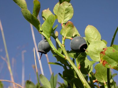
Vaccinium myrtillus - © Parc national des Ecrins - Christophe Albert  Flora
FloraBilberry
Just like the bearberry, the cranberry, the lingonberry and the European blueberry, the bilberry belongs to the Ericaceae family. It is a thick shrub, 20 to 60 cm high, with small leaves that are soft, alternating, oval and finely serrated. From August, the edible berries with their reddish blue flesh - hence their local nickname of gueule noire (black face) - provide a fine reddish colour to the sub-Alpine prairie slopes at the end of summer. It can grow beside the European blueberry (Vaccinium myrtillus) with its white pulp and non-serrated leaves.
Berry-picking is subject to specific regulations : In the Ecrins National Park, a maximum of 1 kg can be picked per person per day, and the use of a berry-picking comb is forbidden.
In the partnership zone of the Ecrins National Park and throughout the Isère department : 1 kg per person per day, with the use of a berry-picking comb forbidden before 15 August.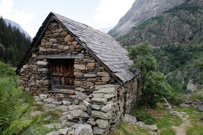
Maison en pierre et toit en ardoise au hameau de la Raja - Cyril Coursier - Parc national des Ecrins  History
The deserted habitat of the Muande valley
The Lavey valley has a dozen deserted high-altitude habitats, including the Raja and Le Souchet. An analysis of charcoals has brought to light a probable habitation of the valley in the 13th century.
The present-day buildings in the valley date from the 18th and 19th centuries.
A number of elements are shared by all the deserted dwellings around St-Christophe en Oisans : high altitude (1,900 to 2,000 m on average), an original architecture made exclusively of dry stone with materials found onsite, and that is very robust, and has a small indoor area (from 8 to 40 m2)
They reveal the existence not only of buildings (houses and outbuildings), but also of an intricate series of walls, terraces and enclosures, dividing the land and corresponding perhaps to older agricultural divisions or to the material form of a complex distribution of land.
They show, above all, the tenacious, exceptional and hard-working presence of human beings who, at the cost of considerable labour, colonised and worked on the smallest parcel of land all the way up to the foot of the rocks and the glaciers.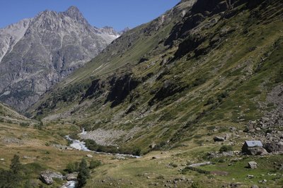
Pastoralisme dans le vallon de la Muande - © Parc national des Ecrins - Mathias Magen  Pastoralism
Pastoralism in the valley
Today, each year, in mid-June, some 800 sheep go up towards the Lavey valley. They are divided into flocks of about 400 animals each, and belong to two Oisans breeders. During the summer, they each occupy one of the slopes, and then return to the valley around 10 October each year. To make sure the two flocks do not mix, the Pierre bridge across the Vénéon has a wooden barrier that must be carefully closed each time visitors go through it. The flock currently grazing on the left bank of the valley has been going up each summer to this Alpine pasture for 35 years was previously led up by a local breeder.
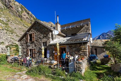
Le refuge de la Lavey - Bertrand Bodin  Hut
HutThe Lavey refuge
This is a refuge in the Ecrins range, at an altitude of 1,797 m in the Lavey valley, which leads to the Vénéon valley.
In 1881, the Isère section of the CAF (Club Alpin Français) bought two buildings in the village of La Lavey. The refuge was renovated and had a storey added to it in 1949 (24 places), and was extended in 1972. It can currently sleep 44 people. The refuge provides access to the lakes of Bèches, Rouies and Muande, with the latter still developing, after the withdrawal of the glacier at the end of the Muande. It is also the starting point towards Tête des Fétoules, Les Rouies, L'Olan, Pointe Maximin, L'Aiguille d'Olan or L'Aiguille des Arias, and a way to pass through the Olan gap towards Le Valjouffrey. One can also pass through the Col de la Lavey to reach the Chardon valley. In winter 2011, a spectacular rock slide, which can still be seen today, with several thousand m3 of rock, occurred near the refuge. The refuge is the culmination of a very fine trail, and famous for its cuisine.
There is also a fine site of climbing stones around the refuge !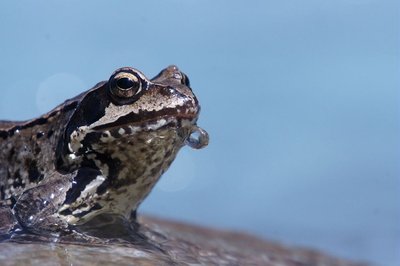
Grenouille rousse dans le Vénéon - Ludovic Imbertis  Fauna
FaunaEuropean common frog
Each year, in late March or early April, when the little pond in front of the Lavey Refuge is filled with water, some forty European common frogs come here to reproduce. Among the forty or so amphibians, some spend the winter hibernating at the bottom of the pond while others make their way here across the snow. This frog is a member of the family of brown frogs and, like its cousin of the plains, has a brown mask extending from behind its eardrum to its eyes. In Europe, the common frog is thought to be the amphibian that can live in the highest altitudes. The frog's spawn is like a compact ball that can contain several hundred eggs floating on top or at the bottom of the pond. The very large number of eggs is needed to guarantee the survival of the species, since very few reach adulthood.
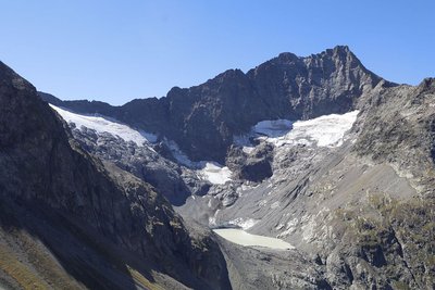
Glacier et lac de la Muande - © Parc national des Ecrins - Martial Bouvier  Panorama
View over Lake Muande
Lake Muande is a glacier lake at an altitude of 2,380 m in the Lavey valley, which leads to the Vénéon valley.
It appeared in the early 1990s, as a result of the withdrawal of the Muande glacier. The absence of a connecting gorge means it occupies the small area behind the confluence tier.
The lake is still emerging, making the site a kind of laboratory where nature is carrying out its powerful creative work.
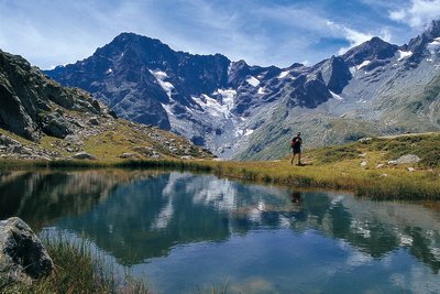
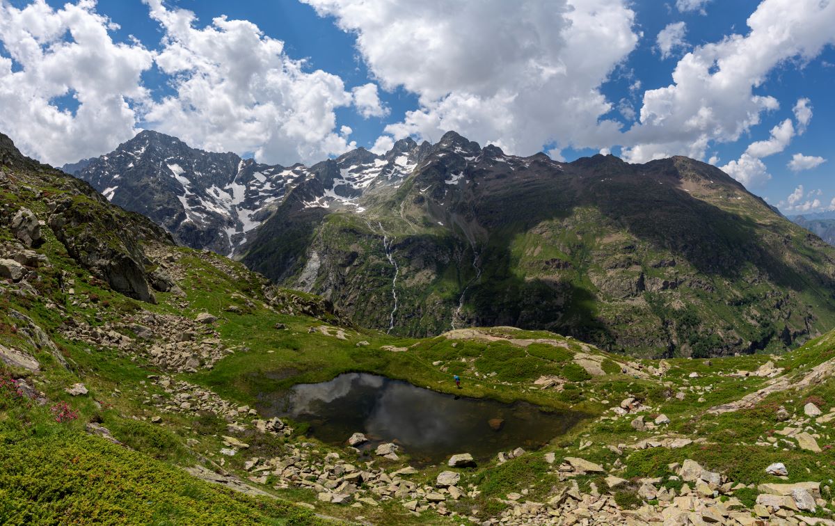
Lac des Fétoules - PNE  Lake
LakeLac des Fétoules
The Lac des Fétoules is a very small lake of approximately 300m2, lying at an altitude of 2,249 metres at the foot of the Tête des Fétoules (3,459 m).
From the lake, the panorama sweeps across the cirque formed by the Aiguille d'Olan, the Aiguilles d'Arias opposite, the Aiguille du Plat de la Selle (3,596 m) to the right and just above, the Tête des Fétoules and the Fétoules glacier.
Grassy stretches surround this little lake.
Forecast
Altimetric profile
Recommandations

 In mountain pastures, protection dogs are there to protect the herds from predators (wolves, etc.).
When I hike I adapt my behavior by going around the herd and pausing for the dog to identify me.
Find out more about the actions to adopt with the article "Protection dogs: a context and actions to adopt".
Tell us about your meeting by answering this survey.
Information desks

Oisans Park house
45 avenue de la République, 38520 Le Bourg d'Oisans
Video presentation of the natural resources of the Oisans mountain and its crafts. Information, documentation about the Park, projections, reading space for children. Accessible to people with reduced mobility. Free admission. All animations of the Park are free unless otherwise stated.

, 38520 Saint-Christophe-en-Oisans - La Bérarde
Access and parking
Follow the D530 to St-Christophe en Oisans
Carry straight on for a further 3 kilometres until you come to the hamlet of Champhorent. The car park is downhill from the D530.
Parking :
Source

Report a problem or an error
If you have found an error on this page or if you have noticed any problems during your hike, please report them to us here: