

Lake Sainte Marguerite
 Medium
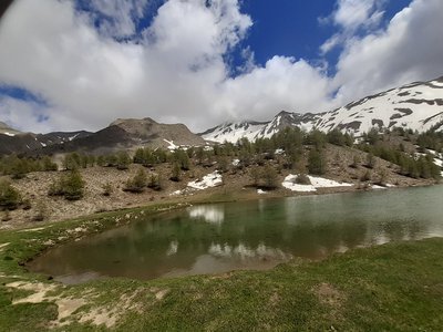
The first part of this hike takes place in the shade of some ancient larch trees, after which the landscape opens up and leads to summer pastures, sometimes described as "cow mountains" by the most experienced mountaineers. The lake, which is hidden from view until the final effort, then appears beneath the peaks reflected in its crystal-clear waters. No need to climb any higher to appreciate the freshness of the setting!
Important information
Dans le Parc national des Écrins, les sentiers sont généralement praticables de la mi-juin à fin septembre.
Toutefois, les périodes d'accessibilité des itinéraires et les dates de pose des passerelles varient d’une année à l’autre en fonction de l’enneigement, des dégâts survenus en hiver et des conditions météorologiques. Par ailleurs, l’état des sentiers n’est pas contrôlé quotidiennement et peut évoluer rapidement après un évènement météorologique (orage, crue...). Il est nécessaire de se renseigner auprès des maisons du parc national et des offices de tourisme du territoire avant votre sortie. Pendant la randonnée, en cas de passage dégradé ou dangereux, faites demi-tour et signalez-le.
Description
- Follow the forest track that starts at the end of the Pra Paisset car park at the bend. After a few hundred meters, continue straight past the Gautier sheepfold. Keep going straight at the intersection with the Via Ferrata sign, 1.8 km from the starting point.
- Then turn left at Pré Lapierre on wide, flat terrain. The path then rises on a steep slope. Veer right 250m higher. Continue straight on a wide path through the larches at the next intersection. Turn left at the Rocher Long sign, then follow a rocky steep path. It disappears when entering an alpine meadow after an ascent of a few hundred meters. It is extended by a small path that crosses the high-altitude meadows near the lake cabins. Then cross the stream and continue on a small path in the pastures. Keep climbing, then turn right at the intersection. Continue as far as the lake.
- Once you reach the lake, you can walk around it. Then retrace your steps to the previous intersection, take the wooden bridge over the river, continue through the pastures, cross a stream, and follow the path that ascends slightly (the stream is likely to disappear in summer). The route becomes more wooded between clearings and undergrowth, then enters a larch forest. Keep straight when crossing the ruins of old cabins. Turn right and follow the sign indicating the return to the resort at the next intersection. At the next intersection in a clearing, follow the direction “Station par le chalet des Fontaines “ "resort via the Fontaines chalet." Continue straight at the next intersection after a descent.
- Once you reach the skiing area, take the wide path that passes under the chairlift. Then follow a small path that goes behind the brasserie restaurant and in front of the Pousterle chairlift, then join the gravel access road and follow it to Les Orres 1800. Then take a right towards Champ Lacas and reach the centre of the resort. Pass under the tunnel towards the shops and join the parking lot on the other side. Take the Bois Méans road at the bend at the exit to the car park. Descend to the hairpin bend below and take a path to the left 20m further on, crossing the balustrade. The path drops down to the Pra Paisset car park.
- Departure : Pré Claux, Les Orres
- Arrival : Pré Claux Les Orres
- Towns crossed : Les Orres
4 points of interest

 Fauna
FaunaRed squirrel
The red squirrel or Eurasian squirrel is an arboreal, diurnal rodent. As its name suggests, it can be found over much of the Eurasian continent, but is nonetheless one of the key species in French coniferous and mixed forests. It weighs an average of 600 grams and measures 18 to 20 cm plus a tail of 16 to 20 cm. Its colour varies from reddish to brownish-black, but its belly is always white. It spends much of its life stocking up on food, seeds or acorns, in preparation for winter. In fact, it does not hibernate and only slows down during this period. Squirrels lead solitary lives and only meet other squirrels when they are breeding. The threat of the grey squirrel, which was imported from North America, is better adapted to deciduous forests and carries a deadly virus for its cousin, is worsening in Europe and could soon spread to the Alps.

Bergerie Gautier - florimont.tilliere  Pastoralism
Gautier Sheepfold
This centuries-old sheepfold was first restored in 1755 during Jean Francois Gautier's term as mayor of Les Orres, after whom it was named, and once again in 2009 after withstanding more than two centuries of weathering. The floor of the sheepfold was laid using the traditional "standing timber" technique. Small, debarked trunks 12 cm high are held vertically by crushed gravel between the trunks.
Lac Sainte Marguerite - florimont.tilliere  Water
WaterLake Sainte Marguerite
Lake Sainte Marguerite lake lies in the high Eysalette valley, surrounded by peaks that almost form an amphitheatre, with the Pic Silhourais and the Alpe de Verdun mountain rising above them. This exceptional setting is complemented by the rich fauna of the lake, which promises a great catch for anglers, particularly the Brown trout, which can also be found in the Eysalettes torrent, which rises in the lake.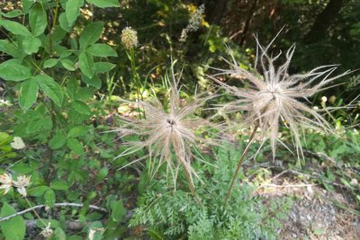
Amélie Vallier - Amélie Vallier  Flora
FloraPasqueflower in fruit
The Alpine Pasqueflower is common in the department. This anemone is found in lawns and undergrowth. Its fruits are achenes, meaning that they do not open. It is a dry fruit that is not intended to be eaten by animals. This means they colonise environments on the wind, which carries them from one place to another.
Forecast
Altimetric profile
Information desks

Transport
Public transport : ccserreponcon.com
Access and parking
Follow the N94 from Gap or Briançon, then the D40 towards Les Orres at Embrun.
Parking :
Accessibility
- Emergency number :
- 114
More information

Source

Report a problem or an error
If you have found an error on this page or if you have noticed any problems during your hike, please report them to us here: