5. From the Refuge du Pigeonnier to the Refuge du Chabournéou
Throughout this Stage, you are up close to high mountain life. You are surrounded by high peaks and can observe the fauna and flora of these habitats which are typical of the Massif des Écrins, a favourite haunt for lovers of mountains and wide-open spaces.
Description
- Head due south towards the Cabane du Vaccicier, then head due east. The path skirts around the ridge which runs down from the Pic Central du Vaccivier. The view gradually opens up onto the huge Vaccicier valley and the highest peak of the Valgaudemar: Le Bans (3,669 m). A large cairn forms a belvedere a few hundred metres beyond the refuge. A tricky stretch (but not exposed) has then to be negotiated. Look carefully to your left and then right again to find the best footholds.
- When you reach a fork, head towards the Cabane du Vaccivier and Gioberney. From here, the path drops back down into the valley. Follow it as far as the Cabane de la Crotte (1,720 m).
- Slightly uphill from it, take the path to Tirière and climb up into sections of glacier-polished rocks and rhododendrons. The view of the southern slope of Les Roules and Lac Lauzon is magnificent. When you arrive at the Tirière plateau, enjoy a rest overlooking the valley and La Chapelle-en-Valgaudemar. Drop down again
- At the next fork, take the path to the Refuge de Chabournéou. The path rises and runs past the Cabane du Pis, a rock shelter that is less Spartan than that of the Vaccivier.
- Cross the mountain stream Le Pis which runs down from the Aupillous glacier, a peak which can be seen on the left, and the north-western face of the Pic Jocelme. The path rises for a short distance until it comes to the Beaume Rousse plateau. The Refuge de Chabournéou suddenly comes into view on the opposite side. Go down the path as it follows the contour line, in order to cross the Chabournéou mountain stream. The views over the various mountain slopes are superb. After this, you soon come to the Refuge de Chabournéou.
- Departure : Refuge du Pigeonnier
- Arrival : Refuge de Chabournéou
- Towns crossed : La Chapelle-en-Valgaudemar
7 points of interest
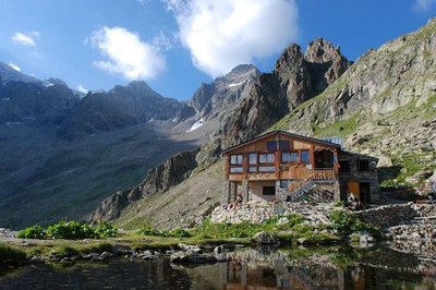
Le refuge du pigeonnier - Jean-Pierre Nicollet - PNE  Hut
HutPigeon Loft Refuge
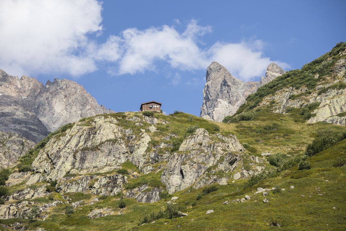
Perched at 2423 m, at the foot of the Rouies, this real eagle’s nest was restored at the beginning of the year 2000. It uses solar energy and offers dry toilets which are signs of the edifice’s environmental integration. Situated almost at the highest point of this hike, it is often the place for a short, beneficial rest, beside the nearby pond.
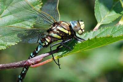
Aeshne des joncs - Olivier Warluzelle - PNE  Fauna
FaunaThe Common Hawker or Sedge Darner
Beside the small pond at the Pigeon Loft refuge, you could have the surprise of seeing this big dragon fly, the Common Hawker, hunting. One of the only kind that lives at these altitudes. Most of its existence is spent as a sub-aquatic larva. Several years under the water are necessary for this great predator to finish its growth and to reach its sexual maturity. From then on, it needs to leave the aquatic environment in order to transform itself into a flying imago (adult). This adult stage only lasts for a few weeks with only one purpose which is reproduction. Mating in flight and the laying of eggs on the surface of the water are carried out in order to finish the life cycle ….with death.
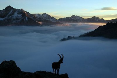
Bouquetin des Alpes - PNE FaunaThe Alpine Ibex
The Alpine Ibex almost disappeared in the 19th century. It owes it survival to the protection put in place in Italy and in La Vanoise National Park which sheltered the last population. Since the beginning of the reintroduction programme of the species initiated successfully in 1989, the ’lord of the summits’ has recovered his place in the Massif des Ecrins. The cirque du Gioberney is a favourite location for the birth of young, at the beginning of the summer, and it provides the calm atmosphere required by this species. Maybe you will be suprised by the massive and majestic silhouette of a male or a very young kid demonstrating its innate mountaineering qualities.
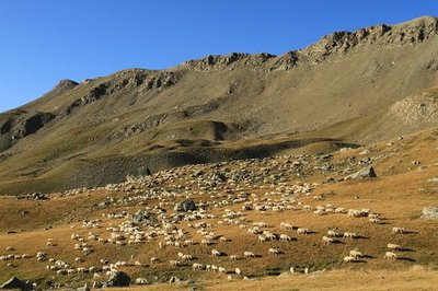
Brebis sur l'alpage - Jean-Philippe Telmon - PNE  Pastoralism
Live at the rhythm of the sheep
Despite the austere terrain, Valgaudemar valley has been the home, for centuries to intense pastoral activity which gives a rhythm to the lives of the inhabitants from spring to the first snows. Here and there, you will discover a shephard’s hut always under the astonished gaze of the sheep belonging to the sheep farms in the valley. The flocks contain different races including « Métisses », « Thônes et Marthod », « Lacaune » and « Mérinos », which are particularly well adapted to the demands of this terrain.
 History
The Chauvetane mine
In the 19th century, the Valgaudemar area experienced a mining rush. Several explorations uncovered a few veins that were the start of mining operations for lead sulphide or argentiferous galena in the Navette valley, at Le Roux or even in La Chauvetane. An English mining company called the "Valgaudemar Mining Company Limited, associated with a Saint-Firmin notary, was founded in 1861. The work of the peasant-miners in the valley, on the steep rock face of the Chauvetane, was essentially to dig out tunnels leading to the veins where the ore was extracted and sent down to the Condamine. There, women would load it onto donkeys and take it down to the present day Xavier Blanc mountain refuge, where it was processed. The operation was not viable however, and the activity finally ceased in 1923.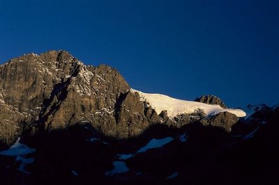
Les Rouies - Olivier Warluzelle - PNE  Panorama
Landscapes and summits
The panorama evolves whilst crossing the Tirière plateau. To start with, walkers have a view of the Gioberney cirque and the surrounding summits, including Les Rouies and its glacier. Further on, the Sirac dominates and the eye is drawn to the Surette valley with a view of the Valgaudemar valley. Opposite, on the other side of the Surette valley, the Morge peak looks like it is poised at the junction of the valleys as a lookout tower.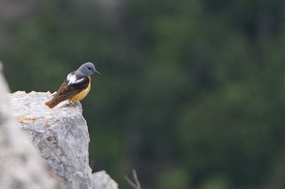
Merle de roche - Pascal Saulay - PNE FaunaHigh altitude birds
The Tirlière plateau is an ideal spot for observing avifauna of the open altitude environment. The song of larks, water pipits and black redstarts will accompany you on this walk. At a bend, you might see a magnificent common rock thrush or a kestrel in the "Holy Spirit" hovering position that makes it easy to identify. Tirière is also a reference site for tracking the chamois population in the Ecrins National Park.
Forecast
Altimetric profile
Recommandations

Information desks

Valgaudemar Park house
Ancien Asile Saint-Paul, 05800 La Chapelle-en-Valgaudemar
Information, documentation and a reception area with permanent and temporary exhibitions. La Maison du Parc is labeled "Tourism and Disability". Free admission. All animations of the Park are free unless otherwise stated.
Source

Report a problem or an error
If you have found an error on this page or if you have noticed any problems during your hike, please report them to us here: