Tour Gourmand
The Gourmet Tour includes a mountainside hike around Saint-Christophe-en-Oisans between the mountain pastures, the secret valleys and some breathtaking panoramas. Each day, everywhere you stay, you enjoy a new culinary speciality.
5 steps
Description
You set off beside the River Vénéon in a valley environment, before soon heading up to spend the night in the mountain pastures in the attractive Alpe du Pin refuge with its local organic cuisine. In the mountain pastures, the trail starts off flat around the mountainside before heading down through a beautiful forest as far as the neighbouring valley of the Lavey, with glaciers, mountain peaks, a welcoming refuge and delicious world cuisine. After a refreshing night, the walk up towards Les Fétoules Lake unveils a superb panorama. Then you go down into the valley before arriving on the south-facing slope, with its lobed-leaved trees and the great mountain cooking at Les Arias gîte. The next day is a long one, calling for plenty of energy, as it takes place on the Plat de la Selle, the highest point of the week, at an altitude of 2,550 m and an unmatched panorama over the Vénéon valley. A mountainous passage leads down to the heights of St-Christophe with its hotels, where you can enjoy some creusets, the speciality of the village. This is a perfect starting point for the last day, which is a relatively easy one, with its attractive path winding its way around the mountainside, between the former farming terraces in the village of Le Puy. One last, fairly steep descent takes us down to the Plan du Lac, the trail's starting and finishing point.
- Departure : Car park next to the Plan du Lac gîte
- Arrival : Car park next to the Plan du Lac gîte
- Towns crossed : Les Deux Alpes and Saint-Christophe-en-Oisans
33 points of interest
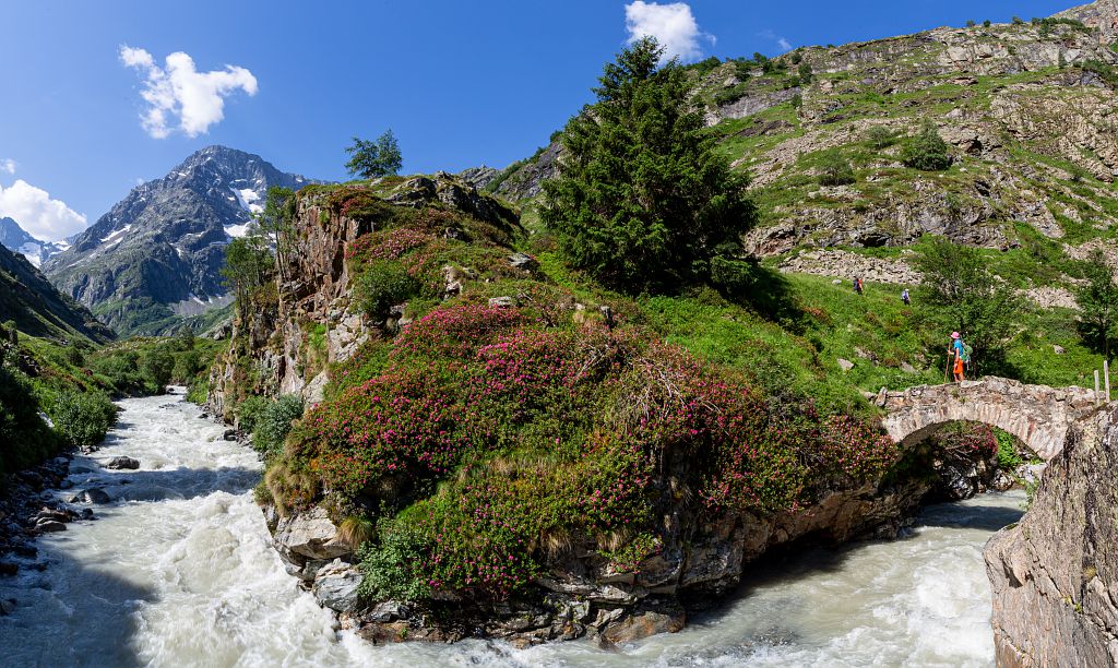
Ripisylve sur le Vénéon, au Plan du Lac - Daniel Roche  Flora
FloraRiparian woodland
Riparian woodland is woodland bordering rivers and streams. This is a highly specific environment, requiring vegetation to adapt to flooding, in particular, and so we can often see fast-growing trees such as willows and alders, and bushes such as the sea buckthorn.
It plays a major role in maintaining biodiversity acts as a filter improving water quality. Riparian woodland has been transformed by mankind's redirecting rivers, totally transforming it or even causing it to disappear altogether. Mountain streams and rivers are among the last places where it can be found intact.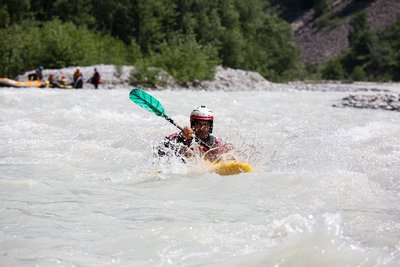
Sport d'eau vive sur le Vénéon - Parc national des Ecrins - Thierry Maillet  Water
WaterWhitewater sports
The Vénéon is an internationally famous river for whitewater sports. Canoeing with a double paddle gives visitors a chance to take on the turbulent waters and keep their heads out of the water using the Eskimo roll technique. Rafting, on a large, inflatable vessel, is very popular with beginners in the company of a guide, and is a big source of thrills and excitement. Here you can also see hot-dogs, a kind of bi-place canoe, and hydrospeeds, a sort of aquatic board sport where you descend the river on your front. Every year, the Vénéon Derby, one of the longest extreme canoeing races in the world, takes place here !
 Water
WaterHydroelectric station
On the right bank of the River Vénéon is a small hydroelectric station. It is called a run-of-the-river station, which means it has no capacity to store water. Water is channelled along a pipe to drive the turbine, which is connected to a generator producing the electricity. There is no dam, so production varies according to the amount of water immediately available, with the maximum amount reached, of course, in spring, when the snow melts.
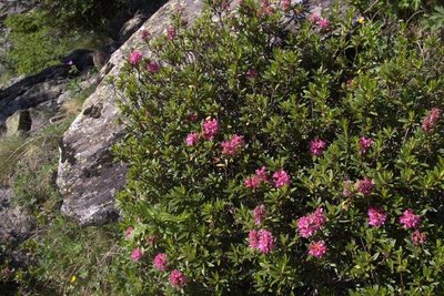
Rhododendron ferrugineux - PNE FloraRhododendron ferrugineum
The rhododendron ferrugineum is a member of the family Ericaceae, like the cranberry, lingonberry and bilberry. It is a bushy shrub, 30 to 100 cm tall and common at altitudes of between 1,400 and 2,500 metres. It retains its leaves all year round. Its leaves are tough, elongated (3 to 5 cm long and 1 to 2 cm across), dark green and glossy on the upper side and yellowish changing to rust on the underside, hence its name "ferrugineum". This particular colouring is due to the presence of russet coloured glands.
In late June to early July, the rhododendron plants are covered in clusters of pink scented flowers which are very attractive to pollinators: it is a bee forage plant.
Just one or two rhododendrons can result in the colonisation of an entire slope.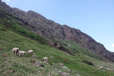
Pastoralisme - PNE  Pastoralism
Animal husbandry in the valley
In summer, some 300 sheep graze the valleys of L'Alpe du Pain and La Mariande.
They are herded up the mountain in early June and brought back down again, lovely and plump, in early October. For four months they are free to roam the high mountain pastures, happily feeding on the rich alpine grass. From time to time, their young owners go up the mountain to tend them. At the end of the season, some linger and it is not unusual to come across them even in late October. They will be gathered by the farmers before the onset of winter.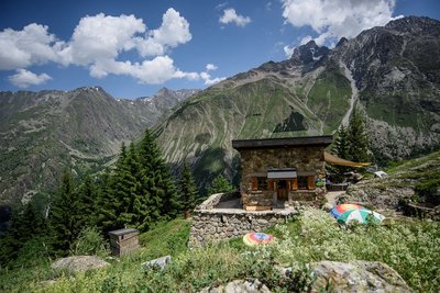
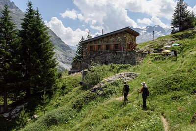
Refuge de l'Alpe du Pin - Parc national des Ecrins - Mireille Coulon  Hut
HutAlpe du Pin Refuge
The Alpe du Pin Refuge is little known and discreet, and stands on the mountain pasture of the same name. It belongs to the Jarrets d'Acier association. It has everything needed to delight the heart, the soul and the calf muscles! Built in 1947, it has preserved its humble origins down the years by making reasonable adaptations to the needs of contemporary comfort. The Alpe du Pin Refuge is located at an altitude of 1,805 m, at the foot of the Tête de Lauranoure (3,325 m), the view of which from St-Christophe leaves no one indifferent. With a capacity of 20 places in a single dormitory, the visitor soon feels at home, and the layout of the refuge helps promote meetings and conversation. You can count on a simple, warm and friendly welcome from the refuge keepers.
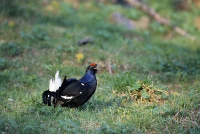
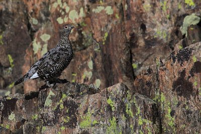
Tétras lyre - Robert Chevalier - PNE  Fauna
FaunaThe habitat of the black grouse
The black grouse is a galliforme (fowl-like) bird and lives at altitudes of between 1,400 and 2,300 metres. It thrives in the semi-open patchwork habitats. These criss-cross habitats of heather moors, grassland and bushes or open woodlands enable it not only to find food for its young (insects, small flowers) in the breeding season (July) but also offers sufficiently tall vegetation cover in which to hide and escape the attention of predators. Song counts are carried out in spring to estimate the number of singing males. Summer counts, using pointer dogs, are also carried out to assess the number of broods in the year.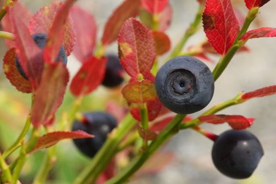
Myrtille commune - Marc Corail FloraThe European blueberry
The European blueberry belongs to the Ericaceae family. It is sub-shrub with dense foliage growing 20 to 60 centimetres tall. Its small leaves are supple, alternating, oval and finely toothed. From August, the edible berries with purplish red pulp, hence its popular name gueule noire (meaning black mouth). They turn the slopes of the sub-alpine meadows a beautiful red colour in late summer. It sometimes grows with the bog bilberry (Vaccinium myrtillus) which has white flesh and smooth leaf edges.
The picking of this berry is subject to special regulation. Within the Parc National des Écrins, it is limited to 1 kg per person per day, and the use of comb-type berry pickers is prohibited. In the area covered by the Parc National des Écrins and throughout the Department of Isère: 1 kg per person per day and the use of comb-type berry pickers is prohibited before 15 August.
Zone humide - PNE FloraWetlands
Wetlands are special habitats characterised by the presence of water - fresh or salt, permanent or temporary. Diverse yet threatened, these environments contribute to shaping the landscapes and constitute an important habitat for numerous animal and plant species. Their conservation is vital if wide biodiversity is to be maintained. High-altitude marshlands or bogs exemplify this.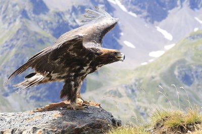
Aigle Royal - Cyril Coursier FaunaThe golden eagle
Once you arrive below the glacial rock bar of La Mariande, you might spot the golden eagle. This majestic bird of prey has dark plumage, the juveniles with beautiful white markings under the wings, soar close to the sunny slopes in order to gain height, looking for prey. It flies alone or with its mate, unlike its cousin, the griffon vulture, which is usually seen in groups. The pair of eagles occupies a large home range, in which several eyries are built. The female usually lays two eggs in the spring. These hatch into eaglets although generally only one will survive. So if you are out walking in late July, keep an eye out - you may be lucky enough to spot a fledged juvenile!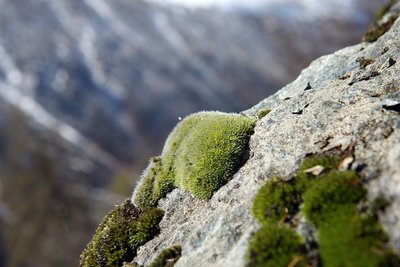
Grimmia alpestris sur un rocher - © Parc national des Ecrins - Cédric Dentant FloraMosses
Bryophytes, more commonly known as mosses, are perfectly adapted to humid woodland environments, and are a vital component in the forest eco-system. A very ancient plant family, they reproduce through an archaic system of spores, and water is needed for their gametes to meet. They do not have roots, strictly speaking, but a system of rhizomes enabling them to be fixed to the soil, to a tree or a rock. They have the particularity of being able to survive when completely dehydrated in times of drought. This is called the reviviscence.
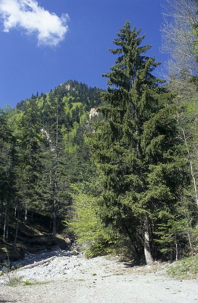
Epicéa - © Parc national des Ecrins - Bernard Nicollet FloraNorway spruce
The cones of the fir tree, firmly fixed on the branches and standing like large candles, are hard to spot since they grow right at the summit of the tree. But the cones of the spruce hang from the end of the branches and fall to the ground when ripe. As for the leaves, the spruce's needles are slightly prickly, but not the fir tree's, which retain a characteristic deep green colour to the point of featuring on colour palettes as "pine green".
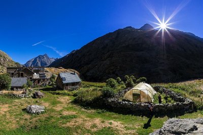
Le hameau du Souchey - Cyril Coursier - Parc national des Ecrins  History
The chalets of Le Souchey
The birth of Alexandre EYMARD in Le Souchet in July 1881 shows that these summer pasture chalets were lived in at that time. Back then, every year, from mid-June to mid-September, the village of Le Souchet was the home of four families. Every summer, the women went with their children up to Le Souchet, while the men stayed in the villages in the valley.
The animals (sheep, goats and cattle) joined in the summer journey. The prairies around the village were mown, the hay gathered in and taken down to the valley in autumn, with the help of a cable running to Champhorent.
The families' livestock included, in general, about two cows, a dozen goats and fifty or so sheep.
In summer, the cows and goats were milked in the morning and evening to make cheese.
In the valley, the men collected the fodder, and some worked as mountain guides, an important extra source of income in the Alps.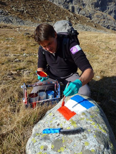
Garde moniteur peignant les limites de la zone coeur du Parc - Cyril Coursier HistoryA flag on the rock: the central area of the National Park.
At the entrance of the Mariande valley, and in the Lavey valley, you can see red, white and blue flags, marking the limits of the central area of the Ecrins National Park, where the regulations apply to protect the natural heritage. The limitation area is regularly maintained by the rangers of the National Park.
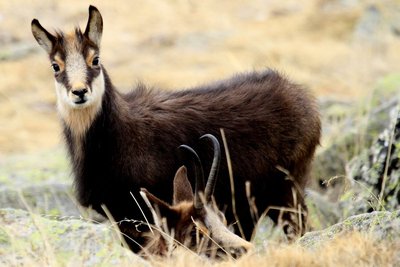
Un chamois - Jean-Philippe Telmon FaunaChamois
An animal symbolising the Alps, the chamois or "goat of the rocks", as it is nicknamed, has short black, hooked horns. Like the Alpine ibex, it is easier to observe with binoculars. The females and young males like to group together in large herds; the older male goats, however, are more solitary and only join the females during the mating season. In winter, the chamois are keen to preserve their tranquillity, since they can only survive by preserving their reserves of fat.
In the Lavey valley, the chamois are most easily seen in spring, when they come down from the high altitudes, attracted by the grass growing, and in autumn, during the breeding season, when it is quite common to see a male chasing another away from one slope to the next.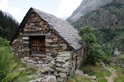
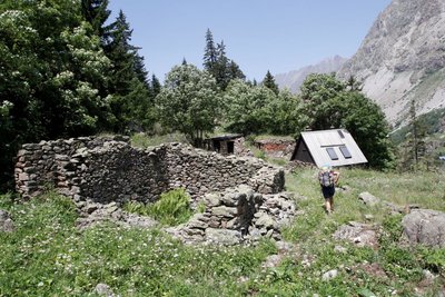
Maison en pierre et toit en ardoise au hameau de la Raja - Cyril Coursier - Parc national des Ecrins HistoryThe deserted habitat of the Muande valley
The Lavey valley has a dozen deserted high-altitude habitats, including the Raja and Le Souchet. An analysis of charcoals has brought to light a probable habitation of the valley in the 13th century.
The present-day buildings in the valley date from the 18th and 19th centuries.
A number of elements are shared by all the deserted dwellings around St-Christophe en Oisans : high altitude (1,900 to 2,000 m on average), an original architecture made exclusively of dry stone with materials found onsite, and that is very robust, and has a small indoor area (from 8 to 40 m2)
They reveal the existence not only of buildings (houses and outbuildings), but also of an intricate series of walls, terraces and enclosures, dividing the land and corresponding perhaps to older agricultural divisions or to the material form of a complex distribution of land.
They show, above all, the tenacious, exceptional and hard-working presence of human beings who, at the cost of considerable labour, colonised and worked on the smallest parcel of land all the way up to the foot of the rocks and the glaciers.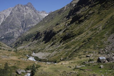
Pastoralisme dans le vallon de la Muande - © Parc national des Ecrins - Mathias Magen PastoralismPastoralism in the valley
Today, each year, in mid-June, some 800 sheep go up towards the Lavey valley. They are divided into flocks of about 400 animals each, and belong to two Oisans breeders. During the summer, they each occupy one of the slopes, and then return to the valley around 10 October each year. To make sure the two flocks do not mix, the Pierre bridge across the Vénéon has a wooden barrier that must be carefully closed each time visitors go through it. The flock currently grazing on the left bank of the valley has been going up each summer to this Alpine pasture for 35 years was previously led up by a local breeder.
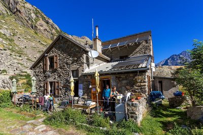
Le refuge de la Lavey - Bertrand Bodin HutThe Lavey refuge
This is a refuge in the Ecrins range, at an altitude of 1,797 m in the Lavey valley, which leads to the Vénéon valley.
In 1881, the Isère section of the CAF (Club Alpin Français) bought two buildings in the village of La Lavey. The refuge was renovated and had a storey added to it in 1949 (24 places), and was extended in 1972. It can currently sleep 44 people. The refuge provides access to the lakes of Bèches, Rouies and Muande, with the latter still developing, after the withdrawal of the glacier at the end of the Muande. It is also the starting point towards Tête des Fétoules, Les Rouies, L'Olan, Pointe Maximin, L'Aiguille d'Olan or L'Aiguille des Arias, and a way to pass through the Olan gap towards Le Valjouffrey. One can also pass through the Col de la Lavey to reach the Chardon valley. In winter 2011, a spectacular rock slide, which can still be seen today, with several thousand m3 of rock, occurred near the refuge. The refuge is the culmination of a very fine trail, and famous for its cuisine.
There is also a fine site of climbing stones around the refuge !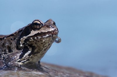
Grenouille rousse dans le Vénéon - Ludovic Imbertis FaunaEuropean common frog
Each year, in late March or early April, when the little pond in front of the Lavey Refuge is filled with water, some forty European common frogs come here to reproduce. Among the forty or so amphibians, some spend the winter hibernating at the bottom of the pond while others make their way here across the snow. This frog is a member of the family of brown frogs and, like its cousin of the plains, has a brown mask extending from behind its eardrum to its eyes. In Europe, the common frog is thought to be the amphibian that can live in the highest altitudes. The frog's spawn is like a compact ball that can contain several hundred eggs floating on top or at the bottom of the pond. The very large number of eggs is needed to guarantee the survival of the species, since very few reach adulthood.
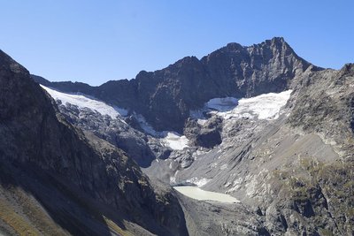
Glacier et lac de la Muande - © Parc national des Ecrins - Martial Bouvier  Panorama
View over Lake Muande
Lake Muande is a glacier lake at an altitude of 2,380 m in the Lavey valley, which leads to the Vénéon valley.
It appeared in the early 1990s, as a result of the withdrawal of the Muande glacier. The absence of a connecting gorge means it occupies the small area behind the confluence tier.
The lake is still emerging, making the site a kind of laboratory where nature is carrying out its powerful creative work.
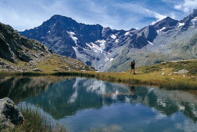
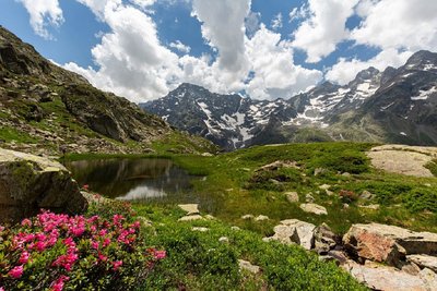
Lac des Fétoules - PNE  Lake
LakeLac des Fétoules
The Lac des Fétoules is a very small lake of approximately 300m2, lying at an altitude of 2,249 metres at the foot of the Tête des Fétoules (3,459 m).
From the lake, the panorama sweeps across the cirque formed by the Aiguille d'Olan, the Aiguilles d'Arias opposite, the Aiguille du Plat de la Selle (3,596 m) to the right and just above, the Tête des Fétoules and the Fétoules glacier.
Grassy stretches surround this little lake.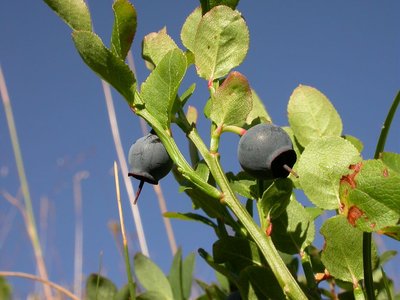
Vaccinium myrtillus - © Parc national des Ecrins - Christophe Albert FloraBilberry
Just like the bearberry, the cranberry, the lingonberry and the European blueberry, the bilberry belongs to the Ericaceae family. It is a thick shrub, 20 to 60 cm high, with small leaves that are soft, alternating, oval and finely serrated. From August, the edible berries with their reddish blue flesh - hence their local nickname of gueule noire (black face) - provide a fine reddish colour to the sub-Alpine prairie slopes at the end of summer. It can grow beside the European blueberry (Vaccinium myrtillus) with its white pulp and non-serrated leaves.
Berry-picking is subject to specific regulations : In the Ecrins National Park, a maximum of 1 kg can be picked per person per day, and the use of a berry-picking comb is forbidden.
In the partnership zone of the Ecrins National Park and throughout the Isère department : 1 kg per person per day, with the use of a berry-picking comb forbidden before 15 August.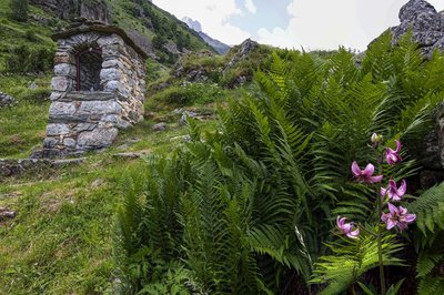
Oratoire de la Raja - Parc national des Ecrins - Thierry Maillet  Vernacular heritage
Oratory of the Virgin and Child in Raja.
In the mountains where the villages are sometimes isolated from each other and too small to have a chapel, oratories were often built. They are mainly small and made of local stone, with an alcove at the centre where a small statue, a plaque or a holy image is placed, representing an important element in religious life. A local place of worship, they are often dedicated to the Virgin Mary or to a saint. They become the goal of a procession or a votive festival for the local population.
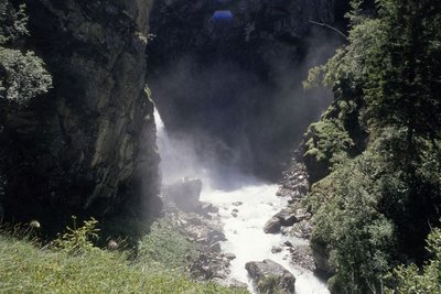
Torrent de montagne - © Parc national des Ecrins - Thierry Maillet WaterMountain streams
Mountain streams are characterised by a sometimes very steep slope and a tumultuous current. Due to the continual intermingling of elements, the water is highly oxygenated and favourable to certain animal species (brown trout, water invertebrates, etc.) that are adapted to the ecological conditions of these ecosystems (even when the water turns to ice !). Mountains streams are also a major factor in erosion due to their role in crushing elements and transporting sediment from the upper slope pools to the large rivers. They represent a very fragile and threatened environment, particularly due to human development, and are among the ecosystems needing to be protected !
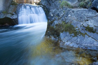
Cascade de la Lavey - Daniel Roche - PNE WaterLa Lavey waterfall
The valley of La Lavey is crossed by the mountain stream La Muande. One hundred and fifty metres upstream from the confluence of this mountain stream with that of the Vénéon, the valley culminates at a gorge and the La Lavey waterfall.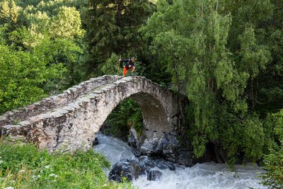
Pont de Pierre sur le Vénéon - Parc national des Ecrins - Thierry Maillet Vernacular heritagePont du Vénéon
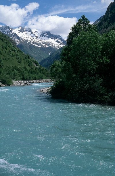
Crossing the Vénéon, this superb stone humpback bridge dates back to the seventeenth century. It is an example of the know-how of our forebears, and the fact that this substantial project was undertaken at all is an indication of the importance of this valley. This bridge also constitutes built evidence of the age-old human occupation of the La Lavey valley. The arch of this bridge was restored in 1972. The structure was decrepit and the joints were completely re-grouted. As you cross the bridge, note the colour of the water of the Vénéon. This is due to fine particles in suspension, the result of erosion of the glaciers in the upper reaches of the Vénéon and dissolved silica from the feldspars contained in the crystalline rocks.
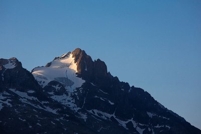
Le glacier et la Tête des Fétoules - Thierry Maillet - Parc national des Ecrins  Top
TopView over Tête des Fétoules
The Tête des Fétoules, a summit in the Ecrins mountains, rises to an altitude of 3,459 metres. Along with the Tête de l'Etret, among others, it is one of a series of peaks separating the Vallon des Etages (to the east) from the Vallon de la Lavey (to the west).
It was first climbed on 29 August 1876 by Emmanuel Boileau de Castelmau with Pierre Gaspard and his son.
Le Lagopède Alpin - Marc Corail FaunaRock ptarmigan
The Alpine forest storey is home to a timid bird that changes its plumage for camouflage : the rock ptarmigan. Once living all over all the continent during the glaciations of the Quaternary period, the species has now withdrawn to the areas providing it with the climatic conditions that best suit it. This fragile population is monitored by the National Park as part of a programme including all the Alpine area, and led by OGM (Observatoire des Galliformes de Montagne). The aim, in particular, is to follow the reproduction of the species each year.
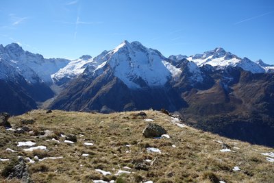
Panorama depuis le Plat de la Selle - © Parc national des Ecrins - Cédric Anglaret PanoramaPanorama from Plat de la Selle
A superb panorama over the Vénéon valley. To the left, on the other side of the valley, is the upper Lavey valley, dominated by the Aiguille des Arias at 3,402 m. At the foot of the Aiguille, the Mariande valley and its characteristic barrier, itself crowned by the Tête de Lauranoure with a peak of 3,325 m above the Alpe du Pin Refuge, which can be seen from below. The next valley is the Lanchatra, with above it the Roche de la Muzelle at an altitude of 3,665 m. A little further on, a village can be seen clearly - Venosc and its cable car, leading to the Deux Alpes ski resort.
Mélezin - © Parc national des Ecrins - Damien Combrisson FloraEuropean larch
The larch is the only European resinous tree to lose its leaves (called needles, because of their shape) in winter. Its wood is reddish brown in colour. In the landscape, it stands out due to its colours, ranging from pale green in spring to the golden colours of autumn. Its pink flowers are celebrated by naturalists and photographers in spring. The European larch is a colonising tree on the mountain slopes. While it can adapt to harsh conditions at high altitude, it cannot hold out against competition with other trees.
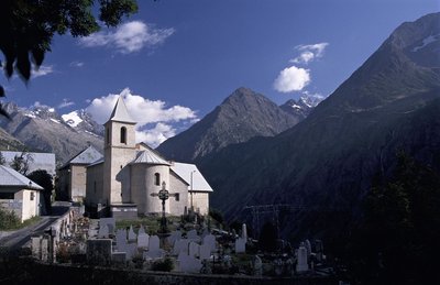
Eglise de St-Christophe-en-Oisans Ville - © Parc national des Ecrins - Denis Fiat Vernacular heritageSaint-Christophe-en-Oisans Church
The church houses a polychromatic wooden statue of Saint Christopher, and another polychromatic and gold wooden statue of the Virgin and child. Both statues date from the 17th century.
Make sure you visit the cemetery behind the church, where a large number of mountain climbers and guides, including the famous Pierre Gaspard, have their resting place.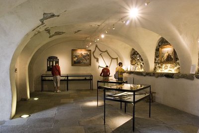
Musée Mémoires de l'alpinisme de St-Christophe-en-Oisans - © Parc national des Ecrins - Pascal Saulay HistoryMusée Mémoires d'Alpinisme
At the centre of the village of Saint-Christophe en Oisans, the Mountain-Climbing Memorial Museum is a treasure trove of knowledge about the major figures who wrote the history of mountain-climbing in the Ecrins range . On the lower level is a large model of the mountain range, with numerous portraits of the pioneers and the equipment of the period. On the second level, the focus in on more recent climbing, with the exploration of tougher routes and a section devoted to the many women - often little known - who have taken part in the adventure of mountain climbing.
The third level is dedicated to temporary exhibitions about the Vénéon valley. This surprising museum is not to be missed !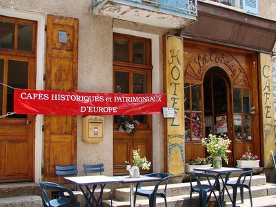
Bar-Hôtel de la Cordée à St-Christophe-en-Oisans Ville - © Parc national des Ecrins - Serge Derivaz  Know-how
Accommodation in Saint-Christophe-en-Oisans
Whether you at La Cordée or the Relais des Ecrins, you are in the commune of St-Christophe. Here you will be welcomed with simplicity, in a small village that has kept its charm and authenticity, with the mountain atmosphere absolutely everywhere and peacefulness abounding.
Marie-Claude Turc, the restaurant owner, whose grandparents opened La Cordée hotel in 1907, will delight you with the Creusets of St-Christophe, the valley's main speciality.
Forecast
Altimetric profile
Sensitive areas
Bearded vulture
- Impacted practices:
- Aerial, , Vertical
- Sensitivity periods:
- JanFebMarAprMayJunJulAugNovDec
- Contact:
- Parc National des Ecrins - Yoann Bunz- 06 99 77 37 65 yoann.bunz@ecrins-parcnational.fr
Bearded vulture
- Impacted practices:
- Aerial, , Vertical
- Sensitivity periods:
- JanFebMarAprMayJunJulAugNovDec
- Contact:
- Parc National des Ecrins - Yoann Bunz- 06 99 77 37 65 yoann.bunz@ecrins-parcnational.fr
Golden eagle
- Impacted practices:
- Aerial, , Vertical
- Sensitivity periods:
- JanFebMarAprMayJunJulAug
- Contact:
- Parc National des Écrins
Julien Charron
julien.charron@ecrins-parcnational.fr
Recommandations
Early in the season, you should ask about snow levels on the trail. Several passages maybe filled with frozen snow. The refuges are open from about mid-June to mid-September. Early in the season, you should ask about snow levels on the trail. Several passages maybe filled with frozen snow. The refuges are open from about mid-June to mid-September. Don't forget to book !

 In mountain pastures, protection dogs are there to protect the herds from predators (wolves, etc.).
When I hike I adapt my behavior by going around the herd and pausing for the dog to identify me.
Find out more about the actions to adopt with the article "Protection dogs: a context and actions to adopt".
Tell us about your meeting by answering this survey.
Information desks

Oisans Park house
45 avenue de la République, 38520 Le Bourg d'Oisans
Video presentation of the natural resources of the Oisans mountain and its crafts. Information, documentation about the Park, projections, reading space for children. Accessible to people with reduced mobility. Free admission. All animations of the Park are free unless otherwise stated.

, 38520 Saint-Christophe-en-Oisans - La Bérarde
Transport
Lines T73-T77 Grenoble – Le Bourg-d’Oisans – Les Deux-Alpes – La Bérarde.
https://carsisere.auvergnerhonealpes.fr/
https://www.itinisere.fr/
Access and parking
From Bourg d'Oisans or La Grave, take the D1091, then the D530 towards Vénosc, and carry on until the Plan du Lac car park. Due to renovation work in the tunnel, the RD 1091 is closed near the Chambon dam, but access is possible along the auxiliary road (access closed to lorries, camping-cars, caravans).
Parking :
More information
Source

Report a problem or an error
If you have found an error on this page or if you have noticed any problems during your hike, please report them to us here: