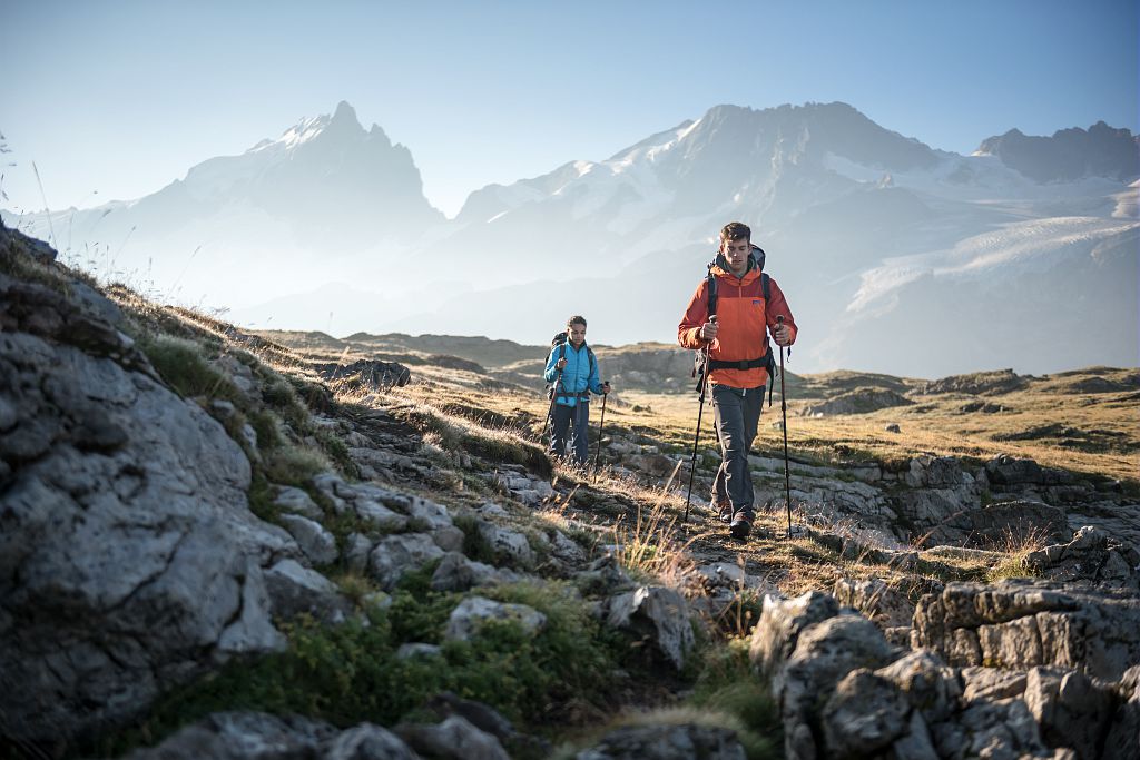
3-day Tour of the Emparis Plateau
Welcome to the land between Isère and Hautes-Alpes. Here, high up in the mountains, the aroma of wild lavender mingles with the freshness of the glaciers. On the way up to the Emparis plateau, each glimpse adds its share of beauty. Below, Lake Chambon; above the majestic summits of Les Ecrins. Tradition, nature and high mountains come together to offer hikers an excursion that will delight both contemplative visitors and fans of mountain heritage.
3 steps
Description
The first, fairly short stage invites hikers to stroll from villages to hamlets, to go up towards the schist paths around the mountains, and leads them to two areas where peace and quiet hold sway. First of all, Lake Lovitel with its discovery trail, then the hamlet of Les Clots, with, above, one of the most beautiful petrified waterfalls in Isère.
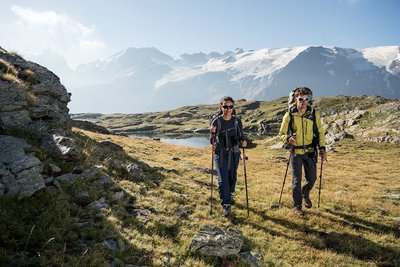
On the 2nd day, you follow a magnificent path along the Pisse torrent, leading you above the waterfall of the same name and the famous petrified fountain. You soon arrive at the Fay and Mouterres refuges along a pastoral path. The path joins up with the GR54 before taking hikers upwards to a unique view over the Emparis plateau and its two landmark lakes: Lake Lerié and Lake Noir. Here the Ecrins glaciers and La Meije are revealed, in one of the finest views over the high mountain summits in the range.
The 3rd stage, gently sloping downwards, goes through mountain pastures and leads through schist paths to Mizoën. We return to civilisation with a glimpse of the life of yesteryear in the ruins of Alpine chalets and farming terraces.
- Departure : Mizoen
- Towns crossed : Mizoën, La Grave, and Besse
4 points of interest
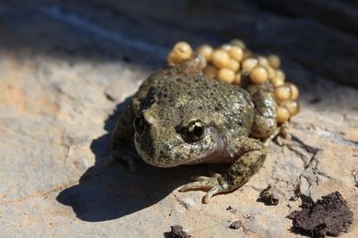
Alyte accoucheur - Marc Corail - PNE  Fauna
FaunaCommon Midwife Toad
In Spring, a short note emitted at regular intervals resonates around the lake. It is the mating season for this small terrestrial grey toad, mottled with black and brown; it is the male toad’s song to attract the females. A peculiarity of this anuran is that the male uses his back legs to surround the string of ova laid by the female to fertilize them with a jet of semen mixed with urine. In this way he watches over the eggs for several weeks. When they are on the point of hatching, he goes to the water and frees the young frogspawn.
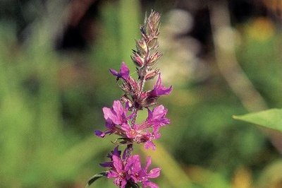
Salicaire - PNE  Flora
FloraPurple Loosestrife
During the whole summer, the Purple Loosestrife, with its beautiful purple spikes, sprinkles the small Lovitel lake with colour. Considered to be a weed to be destroyed, it does however hold a position among the most useful plants (plants with medicinal properties). Its astringent properties, among others, deem it to be a good remedy against colic in infants when teething. In the kitchen, its young shoots and the flesh of its stalks used to be consumed as a vegetable. The leaves could also be infused like tea.
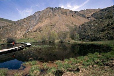
Le sentier de découverte des Clots, Mizoën - Cyril Coursier - PNE  Lake
LakeLovitel Lake
In addition to being one of the rare wetlands at altitude on the highest part of the Romanche, Lovitel Lake unusually partially dries out during the summer and turns in to a marsh. In this way it becomes ideal for the development of amphibians who benefit from the absence of fish, their predators. Furthermore, the ecological quality of the environment is remarkable... Several species of great natural value are present at this site, notably the Adder’s Tongue Fern and the Small Meadow Rue, both protected regionally.
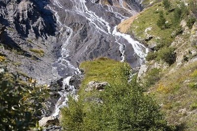
Les Clots, la fontaine pétrifiante - Gérald Lucas  Geology and geography
Petrifying Fountain
The water that crosses the Emparis plateau which is composed of permeable sedimentary rock, fills up with Calcium bicarbonate. When, lower down, it comes in to contact with the impermeable crystalline rock layer of the Hercynien granitic base, the water follows a fault plane established between two layers and finishes in an aerial waterfall. The dissolved carbonates are transformed into a soft rock called Tuff by their contact with the air which has accumulated there for millennium. This resurgence, or petrifying fountain, is one of the most beautiful in France.
Forecast
Altimetric profile
Sensitive areas
Golden eagle
- Impacted practices:
- Aerial, , Vertical
- Sensitivity periods:
- JanFebMarAprMayJunJulAug
- Contact:
- Parc National des Écrins
Julien Charron
julien.charron@ecrins-parcnational.fr
Short-toed snake eagle
- Impacted practices:
- Aerial,
- Sensitivity periods:
- MarAprMayJunJulAugSep
- Contact:
- Parc National des Écrins
Julien Charron
julien.charron@ecrins-parcnational.fr
Recommandations
Mountain biking is forbidden on the GR 50 due to the fragility of the natural environment (decree to protect the biotope).
Camping, fires and water sports (including swimming) are prohibited on the Emparis plateau during the summer. Dogs must be kept on a lead. Bivouacs are permitted between 7pm and 9am.
Information desks

Information center "Col du Lautaret" (summer only)
Col du Lautaret, 05220 Le Monêtier-les-bains
Under the gaze of the Meije (3983 m) and surrounded by beautiful meadows celebrated in the great names of botany, the former hospice of the Lautaret called "refuge Napoleon" houses the reception and information Park center - Projections, documentation, books of the Park. Accessible to people with reduced mobility. Free admission.

Oisans Park house
45 avenue de la République, 38520 Le Bourg d'Oisans
Video presentation of the natural resources of the Oisans mountain and its crafts. Information, documentation about the Park, projections, reading space for children. Accessible to people with reduced mobility. Free admission. All animations of the Park are free unless otherwise stated.
Transport
By bus :
Bus lines in Région Sud : https://zou.maregionsud.fr/
Bus lines in Auvergne-Rhône-Alpes : https://carsisere.auvergnerhonealpes.fr/
Bus lines in Isère : https://www.itinisere.fr/
Access and parking
From Bourg d'Oisans, take the D1091 to Lac du Chambon. After the bridge, leave the departmental road and turn left onto the road to Mizoen.
From Briançon, take the D1091 to Lac du Chambon. After the bridge, leave the departmental road and turn right towards the road leading to Mizoen.
Parking :
More information
Source

Report a problem or an error
If you have found an error on this page or if you have noticed any problems during your hike, please report them to us here: