

Chanteloube mountain bike loop
 Easy
Important information
Dans le Parc national des Écrins, les sentiers sont généralement praticables de la mi-juin à fin septembre.
Toutefois, les périodes d'accessibilité des itinéraires et les dates de pose des passerelles varient d’une année à l’autre en fonction de l’enneigement, des dégâts survenus en hiver et des conditions météorologiques. Par ailleurs, l’état des sentiers n’est pas contrôlé quotidiennement et peut évoluer rapidement après un évènement météorologique (orage, crue...). Il est nécessaire de se renseigner auprès des maisons du parc national et des offices de tourisme du territoire avant votre sortie. Pendant la randonnée, en cas de passage dégradé ou dangereux, faites demi-tour et signalez-le.
Description
- From the station car park, head along the railway line as far as the Intermarché supermarket. Then cross the railway tracks and immediately turn left onto a small road. Go straight on for 400m, then cross the lane to the left and follow the road. Once you reach the main road, turn right onto the main road and then left again 400m further on, towards the hamlet of Miamellon. Continue along this small road past the bridge over the railway line and past the farm.
- Turn left onto a wide carriageway. After several hundred metres, turn right onto another carriageway at the Long Haut sign. Follow the track again for several hundred metres and turn left at the intersection with a new track.
- After a slightly steeper climb, in which the summit offers a clear view of the lake, take a small single-track path to the right and almost immediately right again. The route becomes more sinuous, winding through pine trees. At the bottom of the descent, turn right onto a small path that leads upwards, then left into a clearing. Turn right after returning to the forest, the right and left in succession as Chanteloube Bay comes into view. Continue down a steep descent into the black coombe that plunges down into the bay. Turn left after a series of rounded hillocks in the coombe.
- Once at the car park, head right and take the small road then continue until you pass under a bridge. Turn left just after and cross the bridge. Follow the road as far as the small chapel of Saint Jacques and turn left, still on a small road. At the next junction, take the path on the right. Continue straight ahead, coming to a small road. Return by road via the route taken at the start.
- Departure : Chorges
- Arrival : Chorges
- Towns crossed : Chorges
5 points of interest
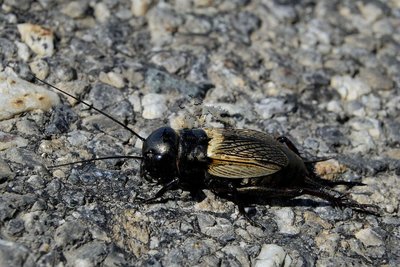
Grillon Champêtre - Mireille Coulon - PNE  Fauna
The field cricket
Just 18 to 26 mm long, this little insect has a black head which looks a little like a helmet. The female can be told apart from the male by the presence of a third long appendage at the rear of the body. The cricket’s song is heard from April onwards. The male sings his chirping song from the entrance to his burrow. The fertile females lay their eggs in the ground, which remain there for two weeks before the larvae emerge.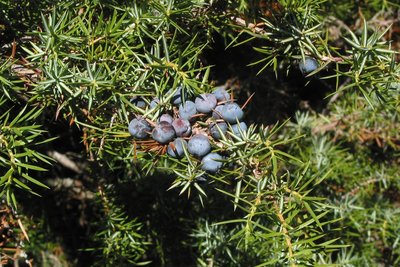
Genévrier commun - Jean-Pierre Nicollet - PNE  Flora
Common juniper
This bush is a resinous evergreen conifer. It is characterised by its greenish to blue (glaucous) needles with a white line on their upper side, and fruits resembling blue-black berries. It usually tends to grow in warm environments receiving plenty of sunlight. It grows in grassy or scrub covered areas up to 2,000 metres above sea level.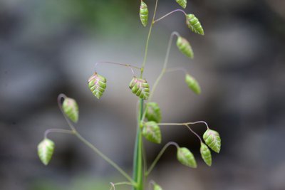
Amourette commune - Bernard Nicollet - PNE FloraQuaking- grass
Quaking-grass or briza media is a plant in the family of upright Poaceae and can reach a height of up to 80 cm. The leaves are 2 to 5 mm wide. The heart-shaped hanging spikelets are coloured purple, changing to yellow as they mature. They tremble in the slightest breeze, hence the name. This very common grass is found in meadows and dry grasslands.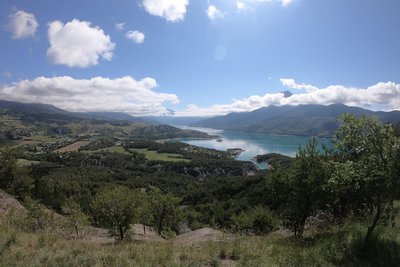
Panorama des Curattes - amelie.vallier  Panorama
Les Curattes Lookout
From the Curattes plateau, visitors can enjoy a picnic table and a panoramic view of the Serre-Ponçon lake, with the imposing Morgon peak in the background. You can also see the coastline of the lake, its wild coves and also the port and seaside area of the Bay of Saint-Michel and the famous chapel of the same name. A little further down is the bridge of Savines-le-Lac. The striking landscape also encompasses the many agricultural and forested areas around Serre-Ponçon.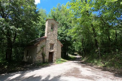
Chapelle St Jacques - Amélie Vallier  Vernacular heritage
Chapel of St-Jacques
Located in Chanteloube, this church is through to date back to 1510. It has retained all its authenticity, with its exposed stone. It is dedicated to Saint James, one of the 12 apostles and one of the first martyrs of the Catholic church. Its recent restoration has made it possible to hold the traditional celebrations there, in honour of Saint James. The purpose of each one is to commemorate a historical event connected with the saint. When he died, he was taken to Compostella in Spain, hence the name of the pilgrim's Way of Saint James to Santiago de Compostella, a religious route passing along the shores of the Serre-Ponçon lake.
Forecast
Altimetric profile
Information desks

Tourist office Chorges
Grand rue, 05230 Chorges
October to may : Monday to Saturday, 9.00 - 12.30 & 13.30 - 17.00.
April, may, june & september : Monday to Saturday, 9.00 - 12.30 & 14.30 - 18.00
July and August : Monday to Saturday, 9:00 – 12.30 & 14.30 – 19.00 Sunday 9.30 – 12.30
Closed on Thursdays outside French holidays’ periods
Closed on French national holidays, except 14th of July and 15th of August
Access and parking
Parking :
Source

Report a problem or an error
If you have found an error on this page or if you have noticed any problems during your hike, please report them to us here: