

Le Col Lebraut
 Easy
Important information
Dans le Parc national des Écrins, les sentiers sont généralement praticables de la mi-juin à fin septembre.
Toutefois, les périodes d'accessibilité des itinéraires et les dates de pose des passerelles varient d’une année à l’autre en fonction de l’enneigement, des dégâts survenus en hiver et des conditions météorologiques. Par ailleurs, l’état des sentiers n’est pas contrôlé quotidiennement et peut évoluer rapidement après un évènement météorologique (orage, crue...). Il est nécessaire de se renseigner auprès des maisons du parc national et des offices de tourisme du territoire avant votre sortie. Pendant la randonnée, en cas de passage dégradé ou dangereux, faites demi-tour et signalez-le.
Description
- From Chorges station, follow the railway line then cross it, heading for Montgardin. The road rises slowly and the hamlet of Montgardin comes into view. At the crossroads, take the left fork and follow the road to Champ Peyron.
- Continue on the main road and cross the Jacques and its well-cleared plateau, with a very fine view of various mountain ranges. At the next crossroads, turn right towards the hamlet of le Fein. The slope steepens as you approach the forest.
- Now cross through the undergrowth, on a sometimes tricky surface, then rejoin the D3 at the Col Lebraut (make a quick round trip to admire the view of the lake and the surrounding mountains).
- Now descend towards Chorges, enjoying the scenery. Pass under the N94 and, 200 m further on, turn left to return to the station car park.
- Departure : Station car park, Chorges
- Arrival : Station car park, Chorges
- Towns crossed : Chorges, Montgardin, and Rousset
1 point of interest
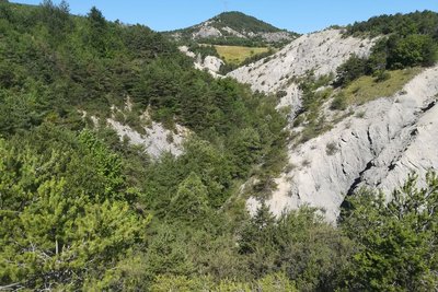
Torrent d'addos - Amélie Vallier  Water
Addos mountain stream
The Addos mountain stream (torrent in French) is 4 kilometres long. A mountain stream is a natural water course located in the mountains. The flow regime is characterised by a steep gradient, with a very fast and therefore turbulent water flow producing significant erosion. It is also defined by a significant variation in flow rate depending on precipitation levels. In this mountain stream, as in many others, numerous small sills (small dams) have been created to slow down the water flow and limit the impact of floods.
Forecast
Altimetric profile
Information desks

Tourist office Chorges
Grand rue, 05230 Chorges
October to may : Monday to Saturday, 9.00 - 12.30 & 13.30 - 17.00.
April, may, june & september : Monday to Saturday, 9.00 - 12.30 & 14.30 - 18.00
July and August : Monday to Saturday, 9:00 – 12.30 & 14.30 – 19.00 Sunday 9.30 – 12.30
Closed on Thursdays outside French holidays’ periods
Closed on French national holidays, except 14th of July and 15th of August
Transport
- Zou! Network : Line 69 / Frequency : Every 4 hours
Route 530 / Frequency 2 times daily
From Embrun:
- Zou! network : Line 69 / Frequency : Every 4 hours
SNCF : TER
More info: https://www.sncf-connect.com
Access and parking
Parking :
More information

Source

Report a problem or an error
If you have found an error on this page or if you have noticed any problems during your hike, please report them to us here: